Science News
Earth Update - April
The Morrison Planetarium’s monthly Earth Update, held as part of “Science Tonight, Live@630” at NightLife, takes visitors on an immersive trip around the world examining current events on our blue planet, including climate, weather, seismic activity and more. The tour is created and navigated by Tim Horn, our producer of climate and earth science visualization and presented by our fearless leader, Ryan Wyatt, director of the Morrison Planetarium and science visualization.
We like to follow up with an article here, informing our readers about the latest earthly news. We usually start and end in our hometown (or relatively nearby), but this month Ryan and Tim began with exoplanets and great news from NASA’s popular Kepler mission: it will continue to look for strange planets for another four years.
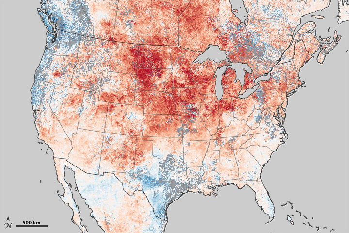
Moving from Kepler, Ryan and Tim took to another NASA satellite, TERRA, which focuses on our planet. Sadly, the image presented (shown here) shows a view of North America’s record-breaking March 2012—the hottest March on record. Temperatures were 8.6 degrees above average, Scientific American reports, mentioning that a NOAA report on the month’s temperatures, “did not just reveal that certain parts of the U.S. had unseasonable warmth; no region was exempt from the weather anomalies.”
From hot to cold… Ryan and Tim then flew north—heading to the Arctic where the sea ice reached its maximum extent for the winter on March 18. NASA’s Earth Observatory notes that,
With a total extent of 15.24 million square kilometers (5.88 million square miles), sea ice was below the 1979–2000 average, but slightly above the record low, which was recorded during the winter of 2010–2011.
How do satellites see Earth’s tornadoes from space? In 3D, of course! Head to NASA’s TRMM satellite’s website to fly through a simulation of last week’s tornadoes in Texas. If that doesn’t provide enough excitement for you, the Huffington Post has a video of trucks being tossed in the air by one of the 12 tornadoes that struck the region on April 3.
Heading farther south, quite a bit farther, Tim and Ryan flew to Antarctica. In early March, the TERRA satellite images detected swirls of green amidst the ice off the Princess Astrid Coast, providing a mystery for scientists familiar with the region. Phytoplankton bloom or green sea ice? Fortunately, an Australian research vessel was nearby and was able to take samples from the area. Their conclusion?
… wind blowing snow off the Amery Ice Shelf in East Antarctica appears to have released nutrients which, combined with sunlight, have triggered a massive algal bloom)... The size of the bloom is estimated to be 200 kilometers by 100 kilometers. Its color is so rich that it is easily visible from space.
Satellites looking toward our planet can even reveal Earth’s crust. Hard to believe? Then head over to Earth Observatory to get a look at the mountains of northeastern Oman. The image
… holds evidence of the creative and destructive forces that shape our planet. The rocks exposed in the Oman Mountains used to lie in Earth’s interior, at the boundary between crust and the mantle, but when the ancient Tethys Ocean narrowed and closed, the forces that squeezed the Tethys also thrust the ancient seafloor skyward.
Ryan and Tim are familiar with these forces as they (along with a talented team of scientists and artists) wrap-up production on the new Morrison Planetarium show about earthquakes, opening in late May. They gave the Nightlife audience a sneak peak as they spoke about the one-year anniversary of the Japanese tsunami. Satellite images of that event are helping scientists grasp the power of these phenomena, including how the debris created from the tsunami moves across the ocean—in some cases, all the way to British Columbia!
Join us next month for Earth Update and/or the new planetarium show.
NASA Earth Observatory image by Jesse Allen, using data from the Level 1 and Atmospheres Active Distribution System (LAADS).