Science News
Antarctic Ice Loss
December 15, 2010
NASA scientists have been tracking West Antarctic ice loss for several years. Satellites are able to see the loss, but from that distance glaciologists were unsure what was driving it.
At a press conference today at the AGU Meeting, NASA researchers presented the cause of loss of massive ice sheets—increased westerly wind speeds over the area.
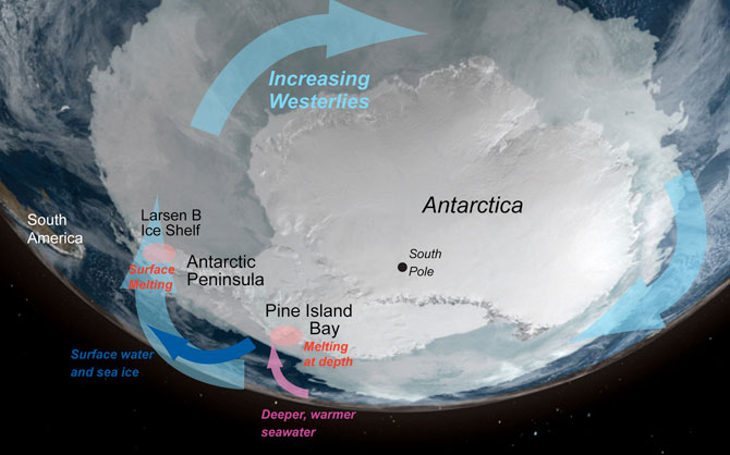
Looking at two areas where ice loss has been the most dramatic—the Larsen B ice shelf and Pine Island Glacier—researchers found the data consistent.
The increased wind speed is dragging surface water along faster, steering the water to the left, pushing it away from the continent (in West Antarctica). Upwelling occurs to fill the gap created, bringing warmer water up from depths below. Much of the ice is melted underneath the ice shelf from this warmer water. This "warmer" water is actually only four degrees Celsius, but that's significant heat for ice.
It's the underneath part that was the “aha” moment for the NASA glaciologists. Impossible to read from satellites above, NASA was able to read the geometry or bathometry of the area using Operation Ice Bridge, an airborne (airplane) mission. The mission began last year to literally "bridge" the gap between satellite data of the region. In addition, instruments have been placed where shelves are disintegrating, bringing more data to the scientists.
The researchers still don’t fully understand what is causing the increase in wind velocity. It could possibly be due to changes in the ozone layer and/or increased greenhouse gases.
NASA hopes that by understanding what's driving the ice loss, they will better project future sea level rise.
Image: NASA/NSIDC