Science News
Earth Update - September
The Morrison Planetarium’s monthly Earth Update, held as part of “Science Tonight, Live@630” at NightLife, takes visitors on an immersive trip around the world examining current events on our blue planet, including climate, weather, seismic activity, and more. The tour is created by Tim Horn, our producer of climate and earth science visualization.
We like to follow up with an article here, informing our readers about the latest earthly news, starting and ending in our hometown (or relatively nearby).
What is all that blue? It’s so dang bright! Could it be that summer is finally arriving here in San Francisco? That’s what we like to think of the warm(-ish), fog-free days of September and October in our city. Fingers crossed that it continues…
…Meanwhile, it seems that all heck is breaking loose on the other side of our country, with hurricanes and seismic activity.
The earthquake in Virginia last month rocked much of the East Coast. Why in Virginia? And why did the seismic waves travel so far?
East Coast earthquakes do happen, just not as frequently as they do for those of us out west. For example, since 1973, the Virginia area has had 2,000 earthquakes, but Southern California ALONE as had over 600,000! Despite this, these eastern earthquakes remain something of a mystery. Virginia isn’t on a major fault line—unlike those of us who straddle the San Andreas or Hayward locally.
East Coast geophysicist Scott Marshall shares his opinion on Appalachian State University’s website:
…the best hypothesis to explain why earthquakes happen in the eastern United States is that ridge push (the force that drives sea floor spreading) from the Mid-Atlantic Ridge is pushing the north American plate westward. Although the plate mostly just moves as a rigid block, occasionally weak spots… slip due to the westward-directed push.
In addition the rock on the East Coast is more solid—less used to the shaking. Again, from Dr. Marshall:
Earthquakes away from plate boundaries are felt over distances up to 10 times farther than equivalent earthquakes at or near plate boundaries. At plate boundaries, rocks at earthquake depths tend to be a lot warmer, softer, and more fractured.
Luckily, damage was minimal. And even though East Coasters had the wrong physical response to earthquakes, they knew what do digitally. Twitter messages moved more quickly than the seismic waves!
And then Hurricane Irene—talk about a one-two punch! Using data from NASA’s Earth Observatory, Tim and trusty presenter Josh Roberts explained to their audience what a hurricane is. These “greatest storms on Earth” have several different names, depending on your location. From Earth Observatory:
In the western Pacific and China Sea area, hurricanes are known as typhoons, from the Cantonese tai-fung, meaning great wind. In Bangladesh, Pakistan, India, and Australia, they are known as cyclones, and finally, in the Philippines, they are known as baguios.
And how do they form?
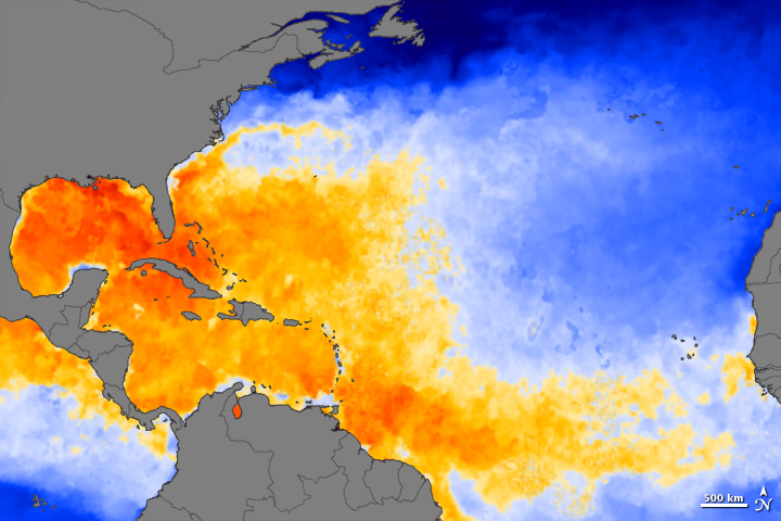
Hurricanes form over tropical waters (between 8 and 20 degrees latitude) in areas of high humidity, light winds, and warm sea surface temperatures [typically 26.5 degrees Celsius (80 Fahrenheit) or greater]. These conditions usually prevail in the summer and early fall months…
You can see the warm sea surface temperatures from August 23 that led to Irene in the image above, also from Earth Observatory.
Water, water everywhere… As with most hurricanes, most of the damage from Irene was caused not by the severe winds, but by heavy rains. Another Earth Observatory article reports that:
Streets flooded in Richmond, Virginia. River flooding around Philadelphia collapsed several buildings. Flooding struck all five boroughs in New York City, and several bridges were wiped out in the Catskills. Floods hit Vermont and New Hampshire harder than expected…
More large storms appear to be a-brewing: Katia appeared over the Atlantic two days ago and Tropical Storm Lee could mean flooding for some of the Gulf Coast states.
These storms are all tracked from above by NOAA and NASA satellites pointed toward the Earth. This week, another NASA satellite provided a different, smaller view of our pale blue dot.
Juno, launched August 5th, is headed toward the largest planet in our solar system, Jupiter, to learn about the planet’s “origins, structure, atmosphere and magnetosphere, and look for a potential solid planetary core,” according to the Juno mission website. On the spacecraft’s journey, it took a look back at Earth and the Moon, captured from about six million miles away.
A little closer to home… Not to be upstaged by events in Virginia, a 4.2 magnitude earthquake struck the San Fernando Valley yesterday. The shallow ‘quake meant shaking was felt for miles—as far away as downtown Los Angeles and Santa Monica.
Speaking of earthquakes, the Morrison Planetarium’s visualization studio has started work on a new show for Spring 2012 on the subject. The team is reminded on a daily basis how our planet is still in motion after 4.5 billion years… Stay tuned for updates on the production.
NASA Earth Observatory image by Jesse Allen, using merged AMSR-E/MODIS data processed and provided by Chelle Gentemann and Frank Wentz, Remote Sensing Systems